System Design Question 14: Design Google Maps – Maps, Search, Routing, Traffic, Navigation & Places
Design a scalable mapping platform for search, navigation, routing, traffic, places, reviews, geocoding, and real-time location services.


Note to Readers
Google Maps is one of those systems where each major component could easily be an article of its own. To keep this post practical and interview-focused, I’ve intentionally stayed at a high level and focused on the key building blocks, trade-offs, and architecture decisions.
I’m also conducting a two-part deep-dive live sessions on Google Maps System Design. Each session will include a 90-minute deep dive and 30 minutes of Q&A, and will be offered in both IST (Event Link) and PST(Event Link) time zones.
We’ll go much deeper into architecture, data models, routing, traffic processing, scalability challenges, and interview-specific approaches to solving such problems.
If there are other System Design topics you’d like to be conducted feel free to share your suggestions.
For System Design coaching, mock interviews, or mentorship, you can connect with me on LinkedIn, IGOA, or MeetAPro.
1. Understand Question as User
We need to design a Google Maps-like system that supports:
Map rendering
Search for places
Geocoding and reverse geocoding
Route planning
Turn-by-turn navigation
Real-time traffic
ETA calculation
Places, ratings, reviews, photos
Offline maps
Location sharing
Business listings
Observability and abuse prevention
The system should work globally, support billions of users, and provide low-latency location-based services.
2. Requirement Gathering
2.1 Functional Requirements
Map Rendering
Users should be able to open the app and see map tiles for their current area.
Support zoom levels, satellite view, street view, terrain view, and labels.
Search / Places
Users can search:
Restaurants
ATMs
Petrol pumps
Hospitals
Addresses
Landmarks
Businesses
Return ranked results based on proximity, relevance, popularity, ratings, and freshness.
Geocoding
Convert address → latitude/longitude.
Example:
"India Gate, Delhi" → 28.6129, 77.2295Reverse Geocoding
Convert latitude/longitude → human-readable address.
Example:
28.6129, 77.2295 → India Gate, New DelhiRouting
Find best route between source and destination.
Support: Car, Bike, Walking, Public transport, Cycling, Multiple stops
Navigation
Provide turn-by-turn navigation.
Show: Current location, Next turn, Distance to next turn, ETA, Lane guidance, Re-routing if user deviates
Real-Time Traffic
Collect speed/location signals from users.
Detect congestion, accidents, road closures, slowdowns.
Update ETA dynamically.
Places, Reviews, Ratings
Businesses can have:
Name, Category, Address, Photos, Opening hours, Ratings, Reviews, Phone number, Website
Offline Maps
Users can download map regions and use basic navigation without internet.
Location Sharing
Users can share live location with friends/family for a limited time.
2.2 Non-Functional Requirements
Scalability
Support billions of users and millions of QPS globally.
Low Latency
Search and map tile loading should be fast.
Routing should return within a few hundred milliseconds to a few seconds.
Accuracy
Location, ETA, address, traffic, and routes should be highly accurate.
Availability
Maps should work even during partial service failures.
Freshness
Traffic and road closures must be updated near real time.
Privacy
User location is highly sensitive. Must enforce strong privacy controls.
Global Support
Support multiple countries, languages, address formats, currencies, road rules, and transport systems.
2.3 Out of Scope
We will not deeply design:
Street View image collection
Satellite image processing
Full public transit agency integrations
ML ranking model internals
Ad platform integration
3. BOE / Capacity Estimation
Assume:
1 billion daily active users
100 billion map tile requests/day
5 billion place searches/day
1 billion route requests/day
500 million active navigation sessions/day
50 million live traffic contributors at peak
Map Tile Requests
100B/day = ~1.15M requests/sec average
Peak could be 5M–10M QPS
Search Requests
5B/day = ~58K QPS average
Peak could be 500K+ QPS
Routing Requests
1B/day = ~11.5K QPS average
Peak could be 100K+ QPS
Location Pings During Navigation
If 50M users send location every 5 seconds:
50M / 5 = 10M location pings/secThis is the heaviest real-time pipeline.
Storage
Map graph, places, reviews, photos, traffic history, and location events can easily reach petabytes.
4. High-Level Design
4.1 Core Services
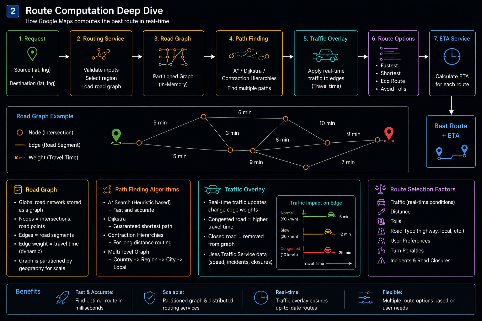
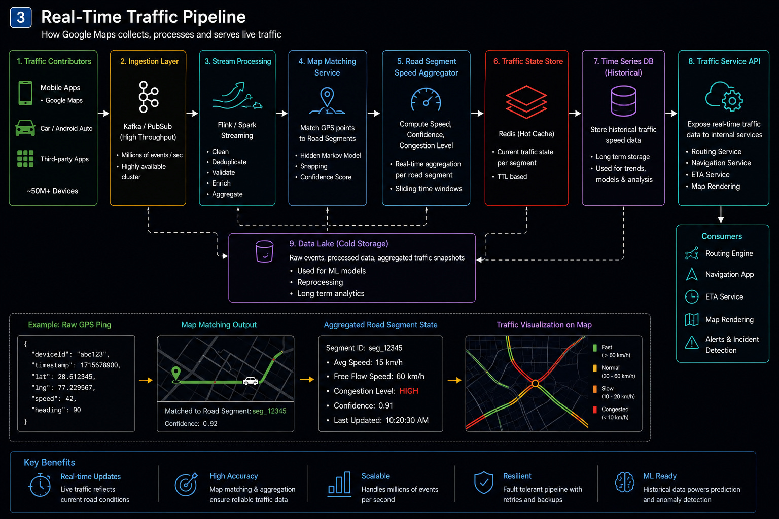
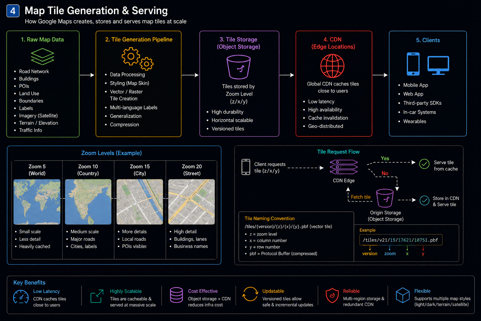
Google Maps can be split into these major services:
Map Tile Service
Place Search Service
Geocoding Service
Reverse Geocoding Service
Routing Service
Navigation Service
Traffic Service
Places / Business Profile Service
Reviews & Ratings Service
Location Sharing Service
Offline Maps Service
Notification Service
Data Ingestion Pipeline
Monitoring & Observability Service
5. Databases and Storage Choices
5.1 Map Tile Service
Use Case
Serve map images/vector tiles quickly.
Storage
Object storage: S3/GCS-like storage
CDN cache
Tile metadata DB
Why
Map tiles are read-heavy and cacheable.
Use CDN aggressively.
5.2 Places Search Service
Use Case
Search nearby places and businesses.
Storage
Elasticsearch / OpenSearch for text search
Geospatial index for nearby queries
Postgres/Cassandra for source of truth
Why
Need both text search and geo-search.
Example query:
restaurants near meNeed ranking by:
distance
rating
popularity
open now
user intent
freshness
5.3 Geocoding Service
Use Case
Address → coordinates.
Storage
Address index
Trie / inverted index
Geo-spatial DB
Search engine
Why
Addresses are messy and country-specific.
Need fuzzy matching.
5.4 Reverse Geocoding Service
Use Case
Coordinates → address.
Storage
Spatial index
Polygon database
Administrative boundary DB
Why
Given a point, find:
street
locality
city
state
country
postal code
5.5 Routing Service
Use Case
Find best path between source and destination.
Storage
Road graph database
Precomputed routing graph
Traffic overlay cache
Data Model
Road network is a graph:
Node = intersection / road point
Edge = road segment
Weight = travel time / distance / traffic-adjusted cost
Algorithms:
Dijkstra
A*
Contraction Hierarchies
Multi-level graph partitioning
5.6 Traffic Service
Use Case
Real-time traffic speed and congestion detection.
Storage
Kafka/PubSub for location pings
Stream processor: Flink/Spark Streaming
Time-series DB
Redis for current traffic state
Data lake for historical traffic
Why
Traffic is real-time and high-volume.
5.7 Reviews & Ratings Service
Use Case
Store reviews, ratings, photos, moderation signals.
Storage
Cassandra / DynamoDB for high-write review storage
Elasticsearch for review search
Object storage for photos
6. APIs
6.1 Map Tile API
GET /maps/tiles/{z}/{x}/{y}Response:
{
  "tileUrl": "https://cdn.maps.com/tiles/12/234/567.vector"
}
6.2 Search API
GET /places/search?query=restaurants&lat=28.61&lng=77.20&radius=5000Response:
{
  "results": [
    {
      "placeId": "p123",
      "name": "ABC Restaurant",
      "lat": 28.61,
      "lng": 77.21,
      "rating": 4.4,
      "openNow": true,
      "distanceMeters": 850
    }
  ]
}
6.3 Geocoding API
GET /geocode?address=India Gate DelhiResponse:
{
  "lat": 28.6129,
  "lng": 77.2295,
  "formattedAddress": "India Gate, New Delhi, India"
}
6.4 Reverse Geocoding API
GET /reverse-geocode?lat=28.6129&lng=77.2295Response:
{
  "address": "India Gate, New Delhi, India"
}
6.5 Routing API
POST /routesPayload:
{
  "source": {
    "lat": 28.61,
    "lng": 77.20
  },
  "destination": {
    "lat": 28.45,
    "lng": 77.02
  },
  "mode": "CAR"
}
Response:
{
  "routeId": "r123",
  "distanceMeters": 32000,
  "etaSeconds": 2700,
  "polyline": "...",
  "steps": [
    {
      "instruction": "Turn right onto Ring Road",
      "distanceMeters": 500
    }
  ]
}
6.6 Navigation Update API
POST /navigation/updatePayload:
{
  "sessionId": "nav123",
  "userId": "u123",
  "lat": 28.62,
  "lng": 77.21,
  "speed": 42,
  "heading": 90,
  "timestamp": 1710000000
}
6.7 Location Sharing API
POST /location/sharePayload:
{
  "userId": "u123",
  "sharedWith": ["u456"],
  "durationMinutes": 60
}
7. Deep Dive into Core Services
A. Map Tile Service
Responsibilities
Serve map tiles based on zoom/x/y
Support vector and raster tiles
Use CDN for global low-latency delivery
Update tiles when roads/businesses change
Flow
User opens map.
Client calculates visible tile coordinates.
Client requests tiles.
CDN serves cached tiles.
If cache miss, request goes to Tile Service.
Tile Service fetches tile from object storage
Response is cached at CDN.
Corner Cases
Cache Miss Storm
Use CDN warmup and regional prefetching.
Stale Tiles
Use versioned tiles.
Example:
/tile/v45/z/x/yDifferent Zoom Levels
Low zoom tiles can be heavily cached.
High zoom tiles need more detail.
B. Place Search Service
Responsibilities
Search places by text and location
Rank nearby results
Support filters like open now, rating, category
Handle spelling mistakes
Ranking Factors
Text relevance
Distance
Popularity
Rating
Freshness
Open now
User history
Business quality score
Flow
User searches “coffee near me”.
API Gateway sends request to Search Service.
Search Service queries Elasticsearch.
Geo-filter limits results by radius.
Ranking service re-ranks top candidates.
Response returns place cards.
Corner Cases
Duplicate Businesses
Use entity resolution.
Fake Listings
Use moderation and trust signals.
Closed Businesses
Need freshness pipeline from owners, users, and web crawl.
C. Geocoding Service
Responsibilities
Convert address to coordinates
Handle typos and abbreviations
Support local address formats
Example
"MG Road Bangalore" → possible multiple matchesReturn ranked candidates.
Components
Address parser
Normalizer
Search index
Geo ranker
Confidence scorer
Corner Cases
Ambiguous Address
Return multiple candidates.
Rural Address
Use landmarks and approximate geocoding.
Wrong Pin Code
Use confidence score and fallback.
D. Reverse Geocoding Service
Responsibilities
Convert lat/lng to address
Find nearest road/building/area
Determine locality/city/state/country
Components
Spatial polygon index
Road segment index
Building footprint DB
Admin boundary DB
Corner Cases
Middle of Highway
Return nearest road and direction.
Border Area
Need precise polygon containment.
Ocean / Empty Area
Return nearest known location or “unknown area”.
E. Routing Service
Responsibilities
Compute fastest route
Compute shortest route
Avoid tolls/highways/ferries
Support multiple transport modes
Use traffic-adjusted edge weights
Road Graph
Vertices: intersections
Edges: road segments
Weights: travel time
Dynamic weight:
effectiveWeight = baseTravelTime + trafficDelay + turnPenalty + roadRestrictionPenaltyRouting Approach
For global scale:
Partition graph by region
Precompute shortcuts
Use A* for local routing
Use contraction hierarchies for long-distance routing
Use traffic overlay for real-time delays
Corner Cases
Road Closure
Mark edge unavailable.
User Takes Wrong Turn
Navigation Service asks Routing Service for re-route.
Multi-Stop Route
Solve as constrained route optimization.
F. Navigation Service
Responsibilities
Maintain active navigation session
Receive user location pings
Match GPS point to road
Detect deviation from route
Trigger re-routing
Update ETA
Flow
User starts navigation.
Routing Service returns route.
Navigation session is created.
User sends location every few seconds.
Map-matching maps GPS point to road segment.
ETA is updated.
If user deviates, trigger re-routing.
Corner Cases
GPS Drift
Use map matching and smoothing.
Tunnel / Low Signal
Use dead reckoning based on last speed and heading.
Wrong Side of Road
Use heading and lane metadata.
G. Traffic Service
Responsibilities
Ingest anonymous location pings
Estimate speed per road segment
Detect congestion
Detect incidents
Feed traffic data into Routing and ETA
Pipeline
Mobile Location Pings
→ Kafka/PubSub
→ Stream Processor
→ Map Matching
→ Segment Speed Aggregator
→ Traffic State Store
→ Routing Service
Data Stored Per Segment
{
  "segmentId": "s123",
  "avgSpeed": 18,
  "freeFlowSpeed": 55,
  "confidence": 0.91,
  "lastUpdated": 1710000000
}
Corner Cases
Sparse Data
Use historical traffic model.
Fake Traffic Attack
Ignore suspicious clustered signals.
Accident Detection
Detect sudden speed drops across multiple users.
H. Places / Business Profile Service
Responsibilities
Store business details
Let owners update information
Validate ownership
Store photos, opening hours, contact details
Data Model
{
  "placeId": "p123",
  "name": "ABC Cafe",
  "category": "CAFE",
  "location": {
    "lat": 28.61,
    "lng": 77.21
  },
  "address": "Connaught Place, Delhi",
  "openingHours": {},
  "phone": "+91...",
  "website": "https://..."
}
Corner Cases
Owner Conflict
Multiple people claim same business.
Spam Listing
Require verification.
Temporarily Closed
Support temporary status updates.
I. Reviews & Ratings Service
Responsibilities
Store user reviews
Calculate aggregate ratings
Detect spam/fake reviews
Support photos and review moderation
Flow
User posts review.
Review Service stores it.
Moderation pipeline checks abuse/spam.
Aggregation service updates rating.
Search ranking uses updated rating.
Corner Cases
Fake Reviews
Use trust score, device signals, account age, visit history.
Abusive Content
Moderation pipeline.
Review Bombing
Detect sudden abnormal rating spikes.
J. Offline Maps Service
Responsibilities
Let users download regional map data
Support offline search and basic routing
Sync updates when online
Data Included
Map tiles
Road graph
Basic places
Address index
Routing metadata
Corner Cases
Stale Offline Data
Show warning if map is old.
Low Storage
Allow selective download.
Offline Routing
Use local graph without live traffic.
8. End-to-End Flow
Flow 1: User Opens Map
App gets current location.
App calculates required tiles.
Tile requests go to CDN.
Tiles render on device.
Nearby labels and places load from Places Service.
Flow 2: User Searches “Petrol Pump Near Me”
Client calls Search API.
Search Service queries place index.
Geo-filter applies radius.
Ranking Service ranks by distance, rating, open status.
Results are returned.
Map shows markers.
Flow 3: User Starts Navigation
User selects destination.
Routing Service computes best route.
Navigation Service creates session.
Client starts sending location pings.
Traffic Service continuously updates road speeds.
Navigation Service updates ETA.
If user deviates, re-routing happens.
Flow 4: Real-Time Traffic Update
Many users send anonymized location pings.
Traffic pipeline map-matches pings to road segments.
Average speed is calculated per segment.
Congestion is detected.
Routing Service uses updated edge weights.
Users see updated ETA and traffic color.
9. Addressing NFRs
A. Scalability
Use:
CDN for map tiles
Regional sharding
Kafka/PubSub for traffic ingestion
Elasticsearch/OpenSearch for search
Redis for hot traffic state
Object storage for tiles/photos
Cassandra/DynamoDB for high-write data
B. Low Latency
Critical paths:
Tile load: CDN-backed
Search: geo-index + cache
Routing: precomputed graph shortcuts
Traffic: Redis hot cache
Navigation: local client-side smoothing + server updates
C. Reliability
Graceful degradation:
If traffic service fails, use historical traffic.
If routing service fails, use cached route.
If search ranking fails, return basic search results.
If CDN misses, fetch from origin.
D. Privacy
Location privacy is critical.
Use:
Location anonymization
Aggregation before traffic calculation
Short retention for raw pings
User consent for location sharing
Encryption at rest and in transit
Strict internal access controls
E. Observability
Track:
Tile latency
Search latency
Routing latency
ETA accuracy
Traffic freshness
Navigation re-route rate
Geocoding success rate
Crash rate
Bad route reports
Spam listings/reviews
10. Final Architecture Summary
Google Maps is a combination of:
Massive read-heavy map tile system
Geo-search engine
Global road graph routing engine
Real-time traffic ingestion pipeline
Navigation session manager
Places and reviews platform
Privacy-first location processing system
The hardest parts are:
Real-time traffic at massive scale
Accurate ETA
Fast routing over global road graph
Fresh map and business data
Search ranking quality
Privacy-preserving location processing
A good interview answer should focus deeply on:
Road graph modeling
Tile serving via CDN
Geo-indexing
Routing algorithms
Traffic pipeline
Map matching
ETA updates
Re-routing
Privacy and scale
Great insights! How would you reroute active navigation sessions when a major highway suddenly closes?